Reading earthquake data
Earthquake depth: shallow, intermediate and deep
Depth tells you where the rupture began below the surface. Reading it properly explains why two earthquakes of almost the same magnitude can feel completely different.
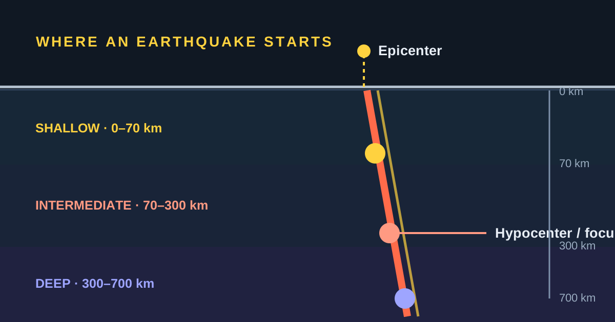
The USGS classifies earthquakes as shallow (0–70 km), intermediate (70–300 km) and deep (300–700 km). At the same magnitude and horizontal distance, a shallow focus usually produces stronger shaking near the rupture — but depth alone never predicts damage.
What earthquake depth actually measures
Focal depth, or hypocentral depth, is the vertical distance between the Earth's surface and the point where the rupture begins. That underground point is the hypocenter or focus. The epicenter is its projection on the surface directly above it.
So a depth of 20 km does not mean the earthquake was 20 km from a city. You may also be tens or hundreds of kilometres from the epicenter. What matters for the shaking that reaches you is the combination of depth and horizontal distance to the rupture — the two together, never the depth alone.
Shallow, intermediate or deep
The USGS divides the roughly 0–700 km range into three scientific zones. They are useful for comparing global catalogs, though a local network may use more specific descriptions for its own territory.
The USGS notes that continental faults, including transform boundaries such as the San Andreas in California, are only active in the shallow crust — to depths of perhaps 20 km. Anything below about 70 km is essentially always tied to a subducting plate.
What 10, 100 or 600 km actually means
Read the number as a property of where the earthquake was located, not as a severity scale. These three cases cover most of what you will see in a catalog:
Interpreting a published depth
| Published depth | Classification | Practical interpretation |
|---|---|---|
| 10 km | Shallow | The rupture is in the crust or very close to it, and can produce intense shaking near the source. If it appears as exactly 10.0 km in a preliminary solution, the value may also be a fixed depth that will be revised later. |
| 100 km | Intermediate | Typical of a plate sinking beneath another. The energy travels through more rock before reaching the surface, and the event may be felt over a wide area. |
| 600 km | Deep | Inside a slab subducted into the mantle. It can be felt at great distances, yet usually produces less surface shaking near the epicenter than an equivalent shallow event. |
Important: do not compare danger using these kilometres alone. You also need the magnitude, the distance to the rupture, the ground type, how long the shaking lasted and how vulnerable the buildings are.
Which is more dangerous, shallow or deep?
At comparable magnitude and horizontal distance, the shallow one usually shakes harder near the source. Its waves pass through less rock before reaching the surface and lose less energy on the way. That is why so many destructive earthquakes belong to the shallow group. The USGS makes the same point in reverse: shaking at the surface from an earthquake 500 km deep is considerably weaker than from the same earthquake at 20 km.
That does not make every shallow earthquake dangerous. A small one may pass unnoticed, while a deep, large one can be felt across several countries. Damage comes from a combination: rupture size, depth, distance, rupture direction, duration, local geology and how the buildings were built.
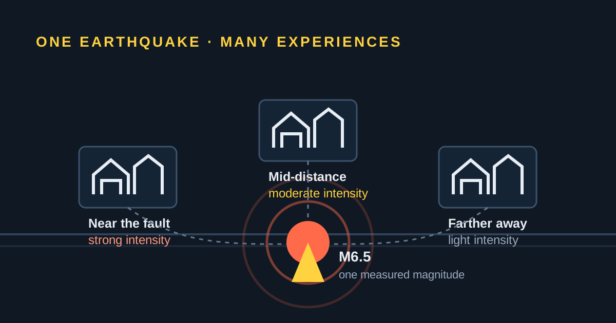
Magnitude describes the size of the event at its source. Intensity describes shaking and observed effects at one particular place. The same earthquake has one preferred magnitude but many different intensities.
Four real earthquakes, four different depths
Nothing makes the point faster than four catalog entries side by side. All figures below come from the USGS event records.
| Earthquake | Depth | Magnitude | What the depth did |
|---|---|---|---|
| Sea of Okhotsk, 24 May 2013 | About 600 km | Mw 8.3 | The largest deep-focus earthquake ever recorded instrumentally. Highest intensity in the USGS record is V, at Severo-Kurilsk — yet it was felt in Moscow, Delhi, Tokyo, Alaska and Seattle. No damage, no tsunami. |
| Nigüelas, Granada, Spain, 11 April 2010 | 610 km | Mw 6.3 | A magnitude that would flatten buildings if it were shallow. From 610 km down it reached intensity III in Málaga and only II in Granada itself. |
| Puebla–Morelos, Mexico, 19 September 2017 | 48 km | Mw 7.1 | An intraslab rupture inside the subducting Cocos plate, about 120 km from Mexico City. Its normal-faulting mechanism and moderate depth put strong shaking directly under the capital: at least 220 people were killed in Mexico City and 44 buildings collapsed there. |
| Haiti, 12 January 2010 | 13 km | Mw 7.0 | Shallow crustal rupture about 30 km from Port-au-Prince. Intensity VIII at Léogâne and VII in the capital, with one of the deadliest outcomes on record for an earthquake of that size. |
The Okhotsk and Granada rows show the deep end of the scale doing what deep earthquakes do: enormous energy, huge felt area, almost no damage. The Mexican event is the one worth studying, because 48 km is neither obviously shallow nor obviously deep. It ruptured inside the descending slab rather than on the plate interface, roughly 120 km from a city built partly on the soft sediments of a former lakebed — ground that amplifies shaking relative to nearby rock. See our page on recent earthquakes in Mexico for how often that setting produces intermediate-depth events.
Where deep earthquakes happen: the Wadati–Benioff zone
Earthquakes deeper than about 70 km are concentrated in subduction zones, where one tectonic plate descends beneath another. Plot their hypocenters in cross-section and they form an inclined band that traces the sinking plate hundreds of kilometres into the mantle. These bands are called Wadati–Benioff zones, and they are how the geometry of a subduction zone — how steeply it dips, whether the slab is flat or bent — was worked out in the first place.
The USGS draws an important distinction inside these zones. The plate-boundary contact itself, the megathrust that produces the very largest shallow earthquakes such as the 2004 Sumatra M9.1 and the 2011 Japan M9.1, is only active to roughly 60 km depth. Everything deeper happens inside the descending slab, which stays cold and brittle relative to the surrounding mantle and can fail down to about 700 km. That is why the deepest earthquakes on Earth cluster beneath places like the Pacific plate under Japan and Kamchatka, and beneath Tonga.
The practical use of this is that depth is a clue to tectonic setting, not only to shaking. A cluster of intermediate-depth events under Chile or Indonesia is the slab; a swarm at 5 km on a continental fault is something else entirely.
The deepest earthquakes in Europe are under Granada
Deep-focus seismicity in Europe is rare, and the deepest of it sits under southern Spain. The USGS catalog holds only six earthquakes deeper than 300 km in the whole Alborán–Betics region, and every one of them is beneath Granada province, at depths between roughly 610 and 635 km — Padul, Nigüelas, Zubia, Lentegí, Güéjar Sierra, Dúrcal. Italy's southern Tyrrhenian slab also produces genuine deep-focus events, but they stop near 500 km.
Two of the Granada events stand out. The largest, on 29 March 1954, is catalogued at Mw 7.8 at 626 km: an earthquake of that magnitude would be catastrophic at crustal depth, and from 626 km down it did comparatively little. The most recent, on 11 April 2010, was Mw 6.3 at 610 km beneath Nigüelas, and produced intensity III in Málaga and II in Granada, Madrid and Valencia; it was felt as far away as Morocco, Algeria and Portugal.
This is exactly why we run a dedicated Granada earthquake page separately from the wider Spain one. Granada's everyday seismicity is shallow, small and frequent; its rare deep events belong to a completely different mechanism and are among the deepest earthquakes recorded anywhere in Europe.
Depth and tsunamis
A tsunami is not generated by shaking. It is generated when the seafloor itself is displaced vertically, lifting or dropping the entire water column above it. That requires the rupture to reach close enough to the seabed to deform it — which is why almost every destructive tsunami in the record comes from a shallow undersea megathrust earthquake, and why depth is one of the first parameters a tsunami warning centre checks. Operational criteria for undersea earthquakes screen at depths under about 100 km.
A rupture 600 km beneath the seabed simply cannot move the water. The Sea of Okhotsk M8.3 is the clean demonstration: one of the most energetic earthquakes of the decade, under the sea, with no tsunami whatsoever. Read depth alongside location — offshore and shallow is the combination that matters.
SeismoWatch is a post-event notification service. We tell you an earthquake has been catalogued; we do not issue tsunami warnings or early warnings. For tsunami guidance, always follow your national warning centre and civil-protection authority.
How earthquake depth is calculated
Seismic networks compare the arrival times and waveforms recorded at multiple stations. The single most accurate method is reading a depth phase: pP, a P wave that travels upward from the hypocenter, reflects off the Earth's surface nearby and then continues out to distant stations. The gap between P and pP changes slowly with distance but rapidly with depth, so pP−P read off a seismogram converts directly into a focal depth using standard travel-time tables. A second phase, sP, is used the same way.
Depth is generally harder to resolve than latitude and longitude, and the USGS says so plainly: errors on depth determinations are somewhat greater than on epicentre determinations, unless a station happens to sit close to and above the epicentre. For teleseismic solutions — the ones computed from distant stations for an earthquake in an under-instrumented region — an uncertainty of several kilometres is routine, and for poorly recorded events it can be considerably more.
That is where the famous 10 km comes from. Ten kilometres is a fixed depth: when the data are too poor to compute a reliable value, the solution assigns 10 km, because in many parts of the world reliable depths average close to that. The USGS used to fix 33 km and moved to 10 km as understanding improved. A useful rule of thumb is that a reliable depth needs the nearest station to be closer to the epicentre than the earthquake is deep — which is exactly why fixed depths are more common for shallow earthquakes than for deep ones. Seeing a run of events all at exactly 10.0 km does not mean they share a layer; it usually means the network coverage was thin.
Why the published depth changes
The first data for any earthquake are preliminary. As more records arrive, an analyst or a new automatic calculation can move the hypocenter and revise the magnitude with it. A change from 10 km to 18 km does not mean the earthquake moved after the fact; it means the estimate of its origin improved.
Check the event's update time whenever an exact depth matters to you. And if you need to make a safety decision, always consult your national seismic and civil-protection authority. Catalogs are scientific tools under continuous revision, not damage forecasts for a specific building.
How to read depth on SeismoWatch
The live earthquake map uses the size of each circle for magnitude and its colour for depth: warm colours for shallow foci, progressively cooler tones for deeper ones. Hovering a marker shows the magnitude, place, time and the depth reported by the catalog.
Every event page on this site also states the depth class in words — Shallow (0–70 km), Intermediate (70–300 km) or Deep (300–700 km) — next to the number, so you never have to remember the boundaries. You can compare patterns across the past seven days or open the regional maps, and each event links to the official record for revisions and technical products.
Compare depths on the live map
Watch how shallow and deep foci arrange themselves around the plate boundaries, and open any event to see its official record.
Frequently asked questions
Is a 10 km deep earthquake shallow?
Yes. Under the USGS classification, any depth from the surface down to 70 km is shallow.
Why do so many catalog entries show exactly 10 km?
Ten kilometres is a fixed depth. When the data are too poor to compute a reliable depth, the USGS assigns 10 km, because reliable depths in many parts of the world average close to that value. A later solution may revise it.
Which is more dangerous, a shallow or a deep earthquake?
At the same magnitude and horizontal distance, a shallow earthquake usually produces stronger shaking near the rupture. The real danger also depends on distance, ground conditions, duration of shaking and how the buildings were constructed.
How deep can earthquakes happen?
Observed seismicity reaches about 700 km. Earthquakes that deep occur inside cold slabs of plate descending into the mantle at subduction zones, where the rock stays brittle enough to fail.
Can a deep earthquake cause a tsunami?
It is very unlikely. A tsunami needs the seafloor itself to move, and a rupture hundreds of kilometres beneath the seabed does not displace the water column above it. Tsunami warning criteria screen for undersea earthquakes at shallow depths.
Is depth the distance between the earthquake and me?
No. Depth is the vertical distance from the hypocenter up to the surface. Your distance to the earthquake also includes how far you are horizontally from the rupture.
Why does the published depth change?
Early solutions are preliminary. As more station data arrive, an analyst or a new calculation can move the hypocenter. A depth revised from 10 km to 18 km does not mean the earthquake moved; it means the estimate improved.
Sources and further reading
- USGS: determining the depth of an earthquake — the depth zones and the pP and sP depth phases.
- USGS FAQ: at what depth do earthquakes occur, and what is the significance of depth? — Wadati–Benioff zones, the 60 km megathrust limit and depth uncertainty.
- USGS FAQ: why do so many earthquakes occur at a depth of 10 km? — the fixed-depth convention and the nearest-station rule of thumb.
- USGS: magnitude, energy release and shaking intensity — including the Northridge and Nisqually depth comparison.
- NOAA: the U.S. tsunami warning system and the U.S. Tsunami Warning Centers.
- USGS event record: 2013 Sea of Okhotsk M8.3, 2017 Puebla–Morelos M7.1, 2010 Haiti M7.0.
- USGS event record: 2010 Nigüelas, Granada M6.3 at 610 km and the 1954 Granada M7.8 at 626 km.